Network of Paths
Overview
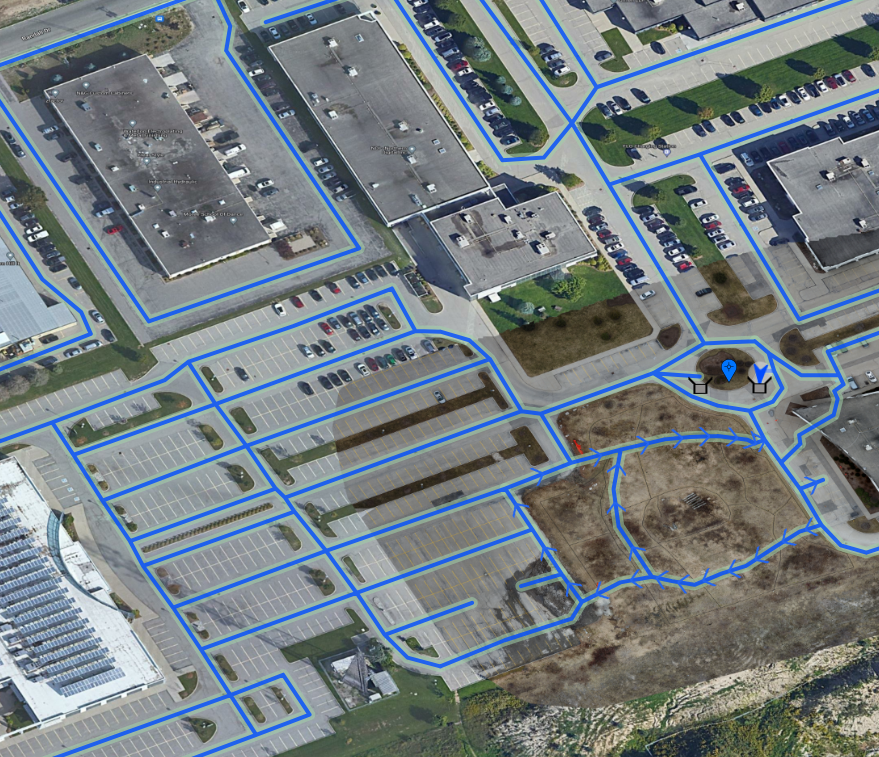
Network of paths uses a directed graph to define the robot's valid driving area. When executing a mission the robot plans its route to follow the edges of the graph to get from waypoint to waypoint. The exact route taken is dynamic and may change depending on the robot's exact starting location, detected obstacles along some edges, and the geometry of the graph itself.
All services in the mission_manager namespace are provided by OutdoorNav's misssion_manager node. This node is part
of the autonomy docker service.
Creating a map
To create a map, use the /mission_manager/create_network_map service:
#!/usr/bin/env python3

import rospy
from clearpath_mission_manager_msgs.srv import *

rospy.init_node("map_maker_example")

map_maker_service = rospy.ServiceProxy("/mission_manager/create_network_map", CreateNetworkMap)
map = map_maker_service("Example Map", 2.5, 1.0, [], []).result

print(map)
This program produces an empty map with an automatically generated UUID:
name: "Example Map"
uuid: "c7c6bd2e-06dd-4f61-9ab0-f81fa896a915"
default_radius: 2.5
default_speed_limit: 1.0
points: []
connections: []
From here you can use the /mission_manager/add_network_point and /mission_manager/add_network_edge services to
add vertices and connect them. However, this can be very slow if your map is large. A faster way is to include the
vertices and edges in the request to create the map:
#!/usr/bin/env python3

import rospy

from clearpath_mission_manager_msgs.msg import *
from clearpath_mission_manager_msgs.srv import *
from clearpath_navigation_msgs.msg import *

# A tuple of (TAG, longitude, latitude, altitude), copied from a Google Earth KML file
# Tags are added manually to identify each coordinate
# The tag is used as a placeholder for the generated UUIDs to simplify defining the edges ourselves
COORDINATES = [
  ("A", -97.28322817327727,50.12300747122199,0),
  ("B", -97.28217525643019,50.12171056479555,0), # the first intersection, connects to C and L
  ("C", -97.28326793963477,50.11981930442499,0), # the second intersection, connects to D and H
  ("D", -97.28483408203536,50.11926816962462,0),
  ("E", -97.28486964915798,50.11761512315844,0),
  ("F", -97.28166555083155,50.11758334859005,0),
  ("G", -97.28229122963415,50.11952637327663,0),
  ("H", -97.28167846932446,50.11913714171172,0), # the third intersection, connects to I and C

  # A dead-end side-branch
  ("I", -97.28219097560832,50.11973533270263,0), # forks from H
  ("J", -97.28249905504131,50.1199092365631,0),
  ("K", -97.28242834054022,50.12013941719884,0),

  # Another dead-end side-branch
  ("L", -97.28242899160524,50.12209511863426,0), # forks from B
  ("M", -97.28246941874356,50.12229616417419,0),
  ("N", -97.28325139122391,50.12230651895854,0),
]

DEFAULT_RADIUS = 2.5
DEFAULT_SPEED_LIMIT = 1.0

rospy.init_node("map_maker_example_2")

map_maker_service = rospy.ServiceProxy("/mission_manager/create_network_map", CreateNetworkMap)
map = map_maker_service(
  "Example Map", DEFAULT_RADIUS, DEFAULT_SPEED_LIMIT,

  # The vertices
  # This is just a simple array of NetworkPoint objects. Each must have a unique ID, a one-letter tag in this
  # example
  [
    NetworkPoint(c[1], c[0], c[2]) for c in COORDINATES  # Note that NetworkPoint uses latitude first!
  ],

  # The edges. This defines the geometry of the map
  # Edges are unidirectional, so we must manually add edges going in both directions where necessary
  [
    NetworkEdgeReq("A", "B", DEFAULT_RADIUS, DEFAULT_SPEED_LIMIT),
    NetworkEdgeReq("B", "A", DEFAULT_RADIUS, DEFAULT_SPEED_LIMIT),

    NetworkEdgeReq("B", "C", DEFAULT_RADIUS, DEFAULT_SPEED_LIMIT),
    NetworkEdgeReq("C", "B", DEFAULT_RADIUS, DEFAULT_SPEED_LIMIT),

    NetworkEdgeReq("C", "D", DEFAULT_RADIUS, DEFAULT_SPEED_LIMIT),
    NetworkEdgeReq("D", "C", DEFAULT_RADIUS, DEFAULT_SPEED_LIMIT),

    NetworkEdgeReq("D", "E", DEFAULT_RADIUS, DEFAULT_SPEED_LIMIT),
    NetworkEdgeReq("E", "D", DEFAULT_RADIUS, DEFAULT_SPEED_LIMIT),

    NetworkEdgeReq("E", "F", DEFAULT_RADIUS, DEFAULT_SPEED_LIMIT),
    NetworkEdgeReq("F", "E", DEFAULT_RADIUS, DEFAULT_SPEED_LIMIT),

    NetworkEdgeReq("F", "G", DEFAULT_RADIUS, DEFAULT_SPEED_LIMIT),
    NetworkEdgeReq("G", "F", DEFAULT_RADIUS, DEFAULT_SPEED_LIMIT),

    NetworkEdgeReq("G", "H", DEFAULT_RADIUS, DEFAULT_SPEED_LIMIT),
    NetworkEdgeReq("H", "G", DEFAULT_RADIUS, DEFAULT_SPEED_LIMIT),

    NetworkEdgeReq("H", "C", DEFAULT_RADIUS, DEFAULT_SPEED_LIMIT), # end of the main road & loop
    NetworkEdgeReq("H", "C", DEFAULT_RADIUS, DEFAULT_SPEED_LIMIT),

    NetworkEdgeReq("H", "I", DEFAULT_RADIUS, DEFAULT_SPEED_LIMIT),
    NetworkEdgeReq("I", "H", DEFAULT_RADIUS, DEFAULT_SPEED_LIMIT),

    NetworkEdgeReq("I", "J", DEFAULT_RADIUS, DEFAULT_SPEED_LIMIT),
    NetworkEdgeReq("J", "I", DEFAULT_RADIUS, DEFAULT_SPEED_LIMIT),

    NetworkEdgeReq("J", "K", DEFAULT_RADIUS, DEFAULT_SPEED_LIMIT),
    NetworkEdgeReq("K", "J", DEFAULT_RADIUS, DEFAULT_SPEED_LIMIT), # end of one fork

    NetworkEdgeReq("B", "L", DEFAULT_RADIUS, DEFAULT_SPEED_LIMIT),
    NetworkEdgeReq("L", "B", DEFAULT_RADIUS, DEFAULT_SPEED_LIMIT),

    NetworkEdgeReq("L", "M", DEFAULT_RADIUS, DEFAULT_SPEED_LIMIT),
    NetworkEdgeReq("M", "L", DEFAULT_RADIUS, DEFAULT_SPEED_LIMIT),

    NetworkEdgeReq("M", "N", DEFAULT_RADIUS, DEFAULT_SPEED_LIMIT),
    NetworkEdgeReq("N", "M", DEFAULT_RADIUS, DEFAULT_SPEED_LIMIT),
  ]
).result

print(map)
The program's output looks like this:
name: "Example Map"
uuid: "3b3bed4e-bcfb-40d4-bc2e-3d5e904890cf"
default_radius: 2.5
default_speed_limit: 1.0
points:
  -
    uuid: "1bef3d7d-3ead-49c7-9306-ede6c4030ebb"
    latitude: 50.12300747122199
    longitude: -97.28322817327727
  -
    uuid: "a56eb1c5-3bee-4d4a-84e0-780651db67cd"
    latitude: 50.12171056479555
    longitude: -97.2821752564302
  -
    uuid: "1efac02f-8dfc-4826-a4cc-894d2cac16f9"
    latitude: 50.11981930442499
    longitude: -97.28326793963477
  -
    uuid: "7bd501a1-ef93-46b9-a440-213755522954"
    latitude: 50.11926816962462
    longitude: -97.28483408203536
  -
    uuid: "9e6c1b11-8430-4986-9091-da440b57df85"
    latitude: 50.11761512315844
    longitude: -97.28486964915798
  -
    uuid: "7a0d3f02-85c3-4907-9bb8-0b2245736b9b"
    latitude: 50.11758334859005
    longitude: -97.28166555083155
  -
    uuid: "0b289f8f-86b8-413f-b35e-cadbd5c4ef31"
    latitude: 50.11952637327663
    longitude: -97.28229122963415
  -
    uuid: "6db9a882-d40b-4050-ad60-3947c4a936d0"
    latitude: 50.11913714171172
    longitude: -97.28167846932446
  -
    uuid: "05b6fb7f-b071-4aa2-b253-1fdf942097c9"
    latitude: 50.11973533270263
    longitude: -97.28219097560832
  -
    uuid: "e77610aa-132d-45b1-83e2-0f8c9b5eafff"
    latitude: 50.1199092365631
    longitude: -97.28249905504131
  -
    uuid: "8a013830-fb3a-4225-84d3-946810dede60"
    latitude: 50.12013941719884
    longitude: -97.28242834054022
  -
    uuid: "d42dd9ce-dc49-4226-ab28-18ac644da0f6"
    latitude: 50.12209511863426
    longitude: -97.28242899160524
  -
    uuid: "aa198f25-78b5-48e0-a9df-750ffb4080a5"
    latitude: 50.12229616417419
    longitude: -97.28246941874356
  -
    uuid: "4d6addba-73f4-4373-8e3c-0f7caf155283"
    latitude: 50.12230651895854
    longitude: -97.28325139122391
connections:
  -
    uuid: "9152c6ee-6cb0-4a6a-a1a3-a156c137e10b"
    start_point:
      uuid: "1bef3d7d-3ead-49c7-9306-ede6c4030ebb"
      latitude: 50.12300747122199
      longitude: -97.28322817327727
    end_point:
      uuid: "a56eb1c5-3bee-4d4a-84e0-780651db67cd"
      latitude: 50.12171056479555
      longitude: -97.2821752564302
    radius: 1.0
    speed_limit: 2.5
    cost_factor: 1.0
  -
    uuid: "af77ee8c-9460-4c4a-bb23-d8eab4877bd8"
    start_point:
      uuid: "a56eb1c5-3bee-4d4a-84e0-780651db67cd"
      latitude: 50.12171056479555
      longitude: -97.2821752564302
    end_point:
      uuid: "1bef3d7d-3ead-49c7-9306-ede6c4030ebb"
      latitude: 50.12300747122199
      longitude: -97.28322817327727
    radius: 1.0
    speed_limit: 2.5
    cost_factor: 1.0
  -
    uuid: "077e176e-531a-4afa-9c55-48496ddb19a3"
    start_point:
      uuid: "a56eb1c5-3bee-4d4a-84e0-780651db67cd"
      latitude: 50.12171056479555
      longitude: -97.2821752564302
    end_point:
      uuid: "1efac02f-8dfc-4826-a4cc-894d2cac16f9"
      latitude: 50.11981930442499
      longitude: -97.28326793963477
    radius: 1.0
    speed_limit: 2.5
    cost_factor: 1.0
  -
    uuid: "8f605876-10d0-43bf-ade3-4acec11b90a4"
    start_point:
      uuid: "1efac02f-8dfc-4826-a4cc-894d2cac16f9"
      latitude: 50.11981930442499
      longitude: -97.28326793963477
    end_point:
      uuid: "a56eb1c5-3bee-4d4a-84e0-780651db67cd"
      latitude: 50.12171056479555
      longitude: -97.2821752564302
    radius: 1.0
    speed_limit: 2.5
    cost_factor: 1.0
  -
    uuid: "98cdf58f-76d1-4b00-8119-44850b20c006"
    start_point:
      uuid: "1efac02f-8dfc-4826-a4cc-894d2cac16f9"
      latitude: 50.11981930442499
      longitude: -97.28326793963477
    end_point:
      uuid: "7bd501a1-ef93-46b9-a440-213755522954"
      latitude: 50.11926816962462
      longitude: -97.28483408203536
    radius: 1.0
    speed_limit: 2.5
    cost_factor: 1.0
  -
    uuid: "94f20e66-aea9-4ea8-8029-31eba37ba800"
    start_point:
      uuid: "7bd501a1-ef93-46b9-a440-213755522954"
      latitude: 50.11926816962462
      longitude: -97.28483408203536
    end_point:
      uuid: "1efac02f-8dfc-4826-a4cc-894d2cac16f9"
      latitude: 50.11981930442499
      longitude: -97.28326793963477
    radius: 1.0
    speed_limit: 2.5
    cost_factor: 1.0
  -
    uuid: "356d56a0-1165-48ef-87ab-b3e289b6d275"
    start_point:
      uuid: "7bd501a1-ef93-46b9-a440-213755522954"
      latitude: 50.11926816962462
      longitude: -97.28483408203536
    end_point:
      uuid: "9e6c1b11-8430-4986-9091-da440b57df85"
      latitude: 50.11761512315844
      longitude: -97.28486964915798
    radius: 1.0
    speed_limit: 2.5
    cost_factor: 1.0
  -
    uuid: "40438b94-fd92-4e95-bb31-1737d235c8ca"
    start_point:
      uuid: "9e6c1b11-8430-4986-9091-da440b57df85"
      latitude: 50.11761512315844
      longitude: -97.28486964915798
    end_point:
      uuid: "7bd501a1-ef93-46b9-a440-213755522954"
      latitude: 50.11926816962462
      longitude: -97.28483408203536
    radius: 1.0
    speed_limit: 2.5
    cost_factor: 1.0
  -
    uuid: "97e40361-123c-4f33-9dae-3bd293d5a001"
    start_point:
      uuid: "9e6c1b11-8430-4986-9091-da440b57df85"
      latitude: 50.11761512315844
      longitude: -97.28486964915798
    end_point:
      uuid: "7a0d3f02-85c3-4907-9bb8-0b2245736b9b"
      latitude: 50.11758334859005
      longitude: -97.28166555083155
    radius: 1.0
    speed_limit: 2.5
    cost_factor: 1.0
  -
    uuid: "5ca07677-1ec9-4355-bfdb-f04801d18feb"
    start_point:
      uuid: "7a0d3f02-85c3-4907-9bb8-0b2245736b9b"
      latitude: 50.11758334859005
      longitude: -97.28166555083155
    end_point:
      uuid: "9e6c1b11-8430-4986-9091-da440b57df85"
      latitude: 50.11761512315844
      longitude: -97.28486964915798
    radius: 1.0
    speed_limit: 2.5
    cost_factor: 1.0
  -
    uuid: "ac299ea0-18f0-42ed-ab82-01c4789c979d"
    start_point:
      uuid: "7a0d3f02-85c3-4907-9bb8-0b2245736b9b"
      latitude: 50.11758334859005
      longitude: -97.28166555083155
    end_point:
      uuid: "0b289f8f-86b8-413f-b35e-cadbd5c4ef31"
      latitude: 50.11952637327663
      longitude: -97.28229122963415
    radius: 1.0
    speed_limit: 2.5
    cost_factor: 1.0
  -
    uuid: "754ad065-c3e8-41de-b0c2-a32e7247db40"
    start_point:
      uuid: "0b289f8f-86b8-413f-b35e-cadbd5c4ef31"
      latitude: 50.11952637327663
      longitude: -97.28229122963415
    end_point:
      uuid: "7a0d3f02-85c3-4907-9bb8-0b2245736b9b"
      latitude: 50.11758334859005
      longitude: -97.28166555083155
    radius: 1.0
    speed_limit: 2.5
    cost_factor: 1.0
  -
    uuid: "dcd5ca9f-5ad7-4404-a6a2-c5ab8b3bb0f5"
    start_point:
      uuid: "0b289f8f-86b8-413f-b35e-cadbd5c4ef31"
      latitude: 50.11952637327663
      longitude: -97.28229122963415
    end_point:
      uuid: "6db9a882-d40b-4050-ad60-3947c4a936d0"
      latitude: 50.11913714171172
      longitude: -97.28167846932446
    radius: 1.0
    speed_limit: 2.5
    cost_factor: 1.0
  -
    uuid: "66884078-ab62-439b-be51-3446cf92809e"
    start_point:
      uuid: "6db9a882-d40b-4050-ad60-3947c4a936d0"
      latitude: 50.11913714171172
      longitude: -97.28167846932446
    end_point:
      uuid: "0b289f8f-86b8-413f-b35e-cadbd5c4ef31"
      latitude: 50.11952637327663
      longitude: -97.28229122963415
    radius: 1.0
    speed_limit: 2.5
    cost_factor: 1.0
  -
    uuid: "948eca22-3bf2-443a-b117-a551c6503c2a"
    start_point:
      uuid: "6db9a882-d40b-4050-ad60-3947c4a936d0"
      latitude: 50.11913714171172
      longitude: -97.28167846932446
    end_point:
      uuid: "1efac02f-8dfc-4826-a4cc-894d2cac16f9"
      latitude: 50.11981930442499
      longitude: -97.28326793963477
    radius: 1.0
    speed_limit: 2.5
    cost_factor: 1.0
  -
    uuid: "9e445547-0e42-4ba4-8411-6228288d3ae8"
    start_point:
      uuid: "6db9a882-d40b-4050-ad60-3947c4a936d0"
      latitude: 50.11913714171172
      longitude: -97.28167846932446
    end_point:
      uuid: "1efac02f-8dfc-4826-a4cc-894d2cac16f9"
      latitude: 50.11981930442499
      longitude: -97.28326793963477
    radius: 1.0
    speed_limit: 2.5
    cost_factor: 1.0
  -
    uuid: "d15e27d7-e4aa-479c-b9bf-705c70ccbdfc"
    start_point:
      uuid: "6db9a882-d40b-4050-ad60-3947c4a936d0"
      latitude: 50.11913714171172
      longitude: -97.28167846932446
    end_point:
      uuid: "05b6fb7f-b071-4aa2-b253-1fdf942097c9"
      latitude: 50.11973533270263
      longitude: -97.28219097560832
    radius: 1.0
    speed_limit: 2.5
    cost_factor: 1.0
  -
    uuid: "1295c8da-65df-4b5b-a214-f7579ad7179d"
    start_point:
      uuid: "05b6fb7f-b071-4aa2-b253-1fdf942097c9"
      latitude: 50.11973533270263
      longitude: -97.28219097560832
    end_point:
      uuid: "6db9a882-d40b-4050-ad60-3947c4a936d0"
      latitude: 50.11913714171172
      longitude: -97.28167846932446
    radius: 1.0
    speed_limit: 2.5
    cost_factor: 1.0
  -
    uuid: "be0f8c9f-0f42-4f9a-9140-050ac617cd10"
    start_point:
      uuid: "05b6fb7f-b071-4aa2-b253-1fdf942097c9"
      latitude: 50.11973533270263
      longitude: -97.28219097560832
    end_point:
      uuid: "e77610aa-132d-45b1-83e2-0f8c9b5eafff"
      latitude: 50.1199092365631
      longitude: -97.28249905504131
    radius: 1.0
    speed_limit: 2.5
    cost_factor: 1.0
  -
    uuid: "6b1a04c8-e5d9-441d-b7d2-5426070d210f"
    start_point:
      uuid: "e77610aa-132d-45b1-83e2-0f8c9b5eafff"
      latitude: 50.1199092365631
      longitude: -97.28249905504131
    end_point:
      uuid: "05b6fb7f-b071-4aa2-b253-1fdf942097c9"
      latitude: 50.11973533270263
      longitude: -97.28219097560832
    radius: 1.0
    speed_limit: 2.5
    cost_factor: 1.0
  -
    uuid: "bee2318d-0e19-427b-aa15-a5aa195212be"
    start_point:
      uuid: "e77610aa-132d-45b1-83e2-0f8c9b5eafff"
      latitude: 50.1199092365631
      longitude: -97.28249905504131
    end_point:
      uuid: "8a013830-fb3a-4225-84d3-946810dede60"
      latitude: 50.12013941719884
      longitude: -97.28242834054022
    radius: 1.0
    speed_limit: 2.5
    cost_factor: 1.0
  -
    uuid: "159619a1-9a8e-41d0-b41b-918b187ac70c"
    start_point:
      uuid: "8a013830-fb3a-4225-84d3-946810dede60"
      latitude: 50.12013941719884
      longitude: -97.28242834054022
    end_point:
      uuid: "e77610aa-132d-45b1-83e2-0f8c9b5eafff"
      latitude: 50.1199092365631
      longitude: -97.28249905504131
    radius: 1.0
    speed_limit: 2.5
    cost_factor: 1.0
  -
    uuid: "79e510bd-5f24-4251-9169-995f30212966"
    start_point:
      uuid: "a56eb1c5-3bee-4d4a-84e0-780651db67cd"
      latitude: 50.12171056479555
      longitude: -97.2821752564302
    end_point:
      uuid: "d42dd9ce-dc49-4226-ab28-18ac644da0f6"
      latitude: 50.12209511863426
      longitude: -97.28242899160524
    radius: 1.0
    speed_limit: 2.5
    cost_factor: 1.0
  -
    uuid: "720679a5-2eda-4f21-b430-9ea34be3076d"
    start_point:
      uuid: "d42dd9ce-dc49-4226-ab28-18ac644da0f6"
      latitude: 50.12209511863426
      longitude: -97.28242899160524
    end_point:
      uuid: "a56eb1c5-3bee-4d4a-84e0-780651db67cd"
      latitude: 50.12171056479555
      longitude: -97.2821752564302
    radius: 1.0
    speed_limit: 2.5
    cost_factor: 1.0
  -
    uuid: "40fdd435-c7da-4e91-895b-e3dd3c872dbd"
    start_point:
      uuid: "d42dd9ce-dc49-4226-ab28-18ac644da0f6"
      latitude: 50.12209511863426
      longitude: -97.28242899160524
    end_point:
      uuid: "aa198f25-78b5-48e0-a9df-750ffb4080a5"
      latitude: 50.12229616417419
      longitude: -97.28246941874356
    radius: 1.0
    speed_limit: 2.5
    cost_factor: 1.0
  -
    uuid: "fff60db8-90ce-484b-ba44-a0637263f727"
    start_point:
      uuid: "aa198f25-78b5-48e0-a9df-750ffb4080a5"
      latitude: 50.12229616417419
      longitude: -97.28246941874356
    end_point:
      uuid: "d42dd9ce-dc49-4226-ab28-18ac644da0f6"
      latitude: 50.12209511863426
      longitude: -97.28242899160524
    radius: 1.0
    speed_limit: 2.5
    cost_factor: 1.0
  -
    uuid: "995875bd-55dd-418b-81cc-72f3d957d119"
    start_point:
      uuid: "aa198f25-78b5-48e0-a9df-750ffb4080a5"
      latitude: 50.12229616417419
      longitude: -97.28246941874356
    end_point:
      uuid: "4d6addba-73f4-4373-8e3c-0f7caf155283"
      latitude: 50.12230651895854
      longitude: -97.28325139122391
    radius: 1.0
    speed_limit: 2.5
    cost_factor: 1.0
  -
    uuid: "9fc59ccd-75a7-4b0a-ab3e-d3c6e9bd9fb9"
    start_point:
      uuid: "4d6addba-73f4-4373-8e3c-0f7caf155283"
      latitude: 50.12230651895854
      longitude: -97.28325139122391
    end_point:
      uuid: "aa198f25-78b5-48e0-a9df-750ffb4080a5"
      latitude: 50.12229616417419
      longitude: -97.28246941874356
    radius: 1.0
    speed_limit: 2.5
    cost_factor: 1.0
Note that in the process of creating the map, all of the points' UUIDs have been regenerated. This is to ensure that all points saved on the robot have unique identifiers.
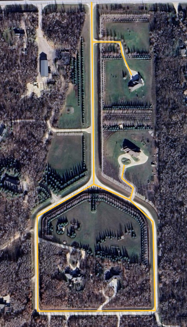
Getting the coordinates for vertices
The coordinates for the vertices in the example above were generated by drawing the desired paths using Google Earth's path tool. The project was exported as a KML file, which can be opened in a text editor:
<?xml version="1.0" encoding="UTF-8"?>
<kml xmlns="http://www.opengis.net/kml/2.2" xmlns:gx="http://www.google.com/kml/ext/2.2" xmlns:kml="http://www.opengis.net/kml/2.2" xmlns:atom="http://www.w3.org/2005/Atom">
<Document>
<name>Untitled</name>
<gx:CascadingStyle kml:id="__managed_style_1EF00888ED2FB5E604EF">
<Style>
<IconStyle>
<Icon>
<href>https://earth.google.com/earth/rpc/cc/icon?color=1976d2&id=2000&scale=4</href>
</Icon>
<hotSpot x="64" y="128" xunits="pixels" yunits="insetPixels"/>
</IconStyle>
<LabelStyle>
</LabelStyle>
<LineStyle>
<color>ff2dc0fb</color>
<width>4</width>
</LineStyle>
<PolyStyle>
<color>40ffffff</color>
</PolyStyle>
<BalloonStyle>
<displayMode>hide</displayMode>
</BalloonStyle>
</Style>
</gx:CascadingStyle>
<gx:CascadingStyle kml:id="__managed_style_2832AC86D92FB5E604EF">
<Style>
<IconStyle>
<scale>1.2</scale>
<Icon>
<href>https://earth.google.com/earth/rpc/cc/icon?color=1976d2&id=2000&scale=4</href>
</Icon>
<hotSpot x="64" y="128" xunits="pixels" yunits="insetPixels"/>
</IconStyle>
<LabelStyle>
</LabelStyle>
<LineStyle>
<color>ff2dc0fb</color>
<width>6</width>
</LineStyle>
<PolyStyle>
<color>40ffffff</color>
</PolyStyle>
<BalloonStyle>
<displayMode>hide</displayMode>
</BalloonStyle>
</Style>
</gx:CascadingStyle>
<StyleMap id="__managed_style_08F931B1C22FB5E604EF">
<Pair>
<key>normal</key>
<styleUrl>#__managed_style_1EF00888ED2FB5E604EF</styleUrl>
</Pair>
<Pair>
<key>highlight</key>
<styleUrl>#__managed_style_2832AC86D92FB5E604EF</styleUrl>
</Pair>
</StyleMap>
<Placemark id="00CEDFEAA82F6E7DC6A6">
<name>Main Path</name>
<LookAt>
<longitude>-97.28114320519418</longitude>
<latitude>50.1207190898435</latitude>
<altitude>255.3655780539208</altitude>
<heading>1.174355479883316</heading>
<tilt>0</tilt>
<gx:fovy>35</gx:fovy>
<range>1653.897493233089</range>
<altitudeMode>absolute</altitudeMode>
</LookAt>
<styleUrl>#__managed_style_08F931B1C22FB5E604EF</styleUrl>
<LineString>
<coordinates>
-97.28322817327727,50.12300747122199,0 -97.28326793963477,50.11981930442499,0 -97.28483408203536,50.11926816962462,0 -97.28486964915798,50.11761512315844,0 -97.28166555083155,50.11758334859005,0 -97.28167846932446,50.11913714171172,0 -97.28229122963415,50.11952637327663,0 -97.28219097560832,50.11973533270263,0 -97.28249905504131,50.1199092365631,0 -97.28242834054022,50.12013941719884,0
</coordinates>
</LineString>
</Placemark>
<Placemark id="0DDE7678C62F6E7DF885">
<name>Side Path</name>
<LookAt>
<longitude>-97.28114320516248</longitude>
<latitude>50.1207190898435</latitude>
<altitude>255.3655780539208</altitude>
<heading>1.174355479883316</heading>
<tilt>0</tilt>
<gx:fovy>35</gx:fovy>
<range>1653.897493233089</range>
<altitudeMode>absolute</altitudeMode>
</LookAt>
<styleUrl>#__managed_style_08F931B1C22FB5E604EF</styleUrl>
<LineString>
<coordinates>
-97.28217525643019,50.12171056479555,0 -97.28242899160524,50.12209511863426,0 -97.28246941874356,50.12229616417419,0 -97.28325139122391,50.12230651895854,0
</coordinates>
</LineString>
</Placemark>
</Document>
</kml>
The <coordinate> tags contain space-separated lists of the form lon_0,lat_0,alt_0 lon_1,lat_1,alt_1 lon_2,lat_2,alt_2 ....
By copying these lists into Python and converting them to Lists or Tuples you can create the lists of coordinates:
# KML coordinates:
# <coordinates>
#   -97.28217525643019,50.12171056479555,0 -97.28242899160524,50.12209511863426,0 -97.28246941874356,50.12229616417419,0 -97.28325139122391,50.12230651895854,0
# </coordinates>

lon_lat_alt = [
  (-97.28217525643019, 50.12171056479555, 0),
  (-97.28242899160524, 50.12209511863426, 0),
  (-97.28246941874356, 50.12229616417419, 0),
  (-97.28325139122391, 50.12230651895854, 0)
]
Executing a mission
To execute a Network of Paths mission, you need to know the UUID of the mission to execute and the UUID of the map. The UUIDs are generated when the objects are created, so you may need to search the available objects to determine the appropriate mission & map if you have more than one.
from clearpath_mission_manager_msgs.msg import *
from clearpath_mission_manager_msgs.srv import *

import actionlib
import rospy

# 1) Get all of the Network of Paths maps and missions from the mission manager
all_maps_srv = rospy.ServiceProxy("/mission_manager/get_all_network_maps", GetAllNetworkMaps)
all_missions_srv = rospy.ServiceProxy("/mission_manager/get_all_network_missions", GetAllNetworkMissions)
maps = all_maps_srv()
missions = all_missions_srv()

# Do a simple search for the map with the desired name
# You can replace the name, or search for any other attribute of the NetworkMap object
map = None
for m in maps:
    if m.name == "My Map":
        map = m
        break

# As above, but looking for the desired mission instead of the desired map
mission = None
for m in missions:
    if m.name == "My Mission":
        mission = m
        break


# we have the map & the mission; we can run the mission
if map and mission:
    # 1) create the actionlib client
    mission_execution_client = actionlib.SimpleActionClient("/autonomy/network_mission", ExecuteNetworkMissionByUuidAction)

    # 2) create the goal
    goal = ExecuteNetworkMissionByUuidGoal(mission.uuid, map.uuid)

    # 3) send the goal to the server
    mission_execution_client.send_goal(goal)

    # 4) Wait for the mission to finish executing
    mission_execution_client.wait_for_result()